Trail Walking La Palud-sur-Verdon - Chalet de la Maline - Point Sublime - Photo
 LtZIP
LtZIP

User

© OpenStreetMap contributors
Length
Length
14.4 km
Max alt
Max alt
901 m
Uphill gradient
Uphill gradient
983 m
Km-Effort
Km-Effort  
28 km
Min alt
Min alt
556 m
Downhill gradient
Downhill gradient
1079 m
Boucle
Boucle
No
Creation date :
2024-03-20 08:24:32.169
Updated on :
2024-03-21 11:00:17.746

(0 Reviews)

Walking
Walking
6h19
Difficulty : Very difficult

Scan this QR Code to open this trail in the SityTrail application

FREE GPS app for hiking

Logo SityTrail SityTrail

IGN / Geographical institutes

Download SityTrail from the App Store Download SityTrail from Google Play

Logo SityTrail SityTrail World

The world is yours!

Download SityTrail from the App Store Download SityTrail from Google Play Download SityTrail on Huawei AppGallery

About

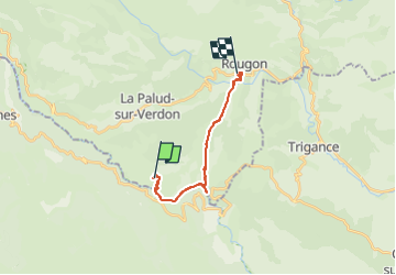
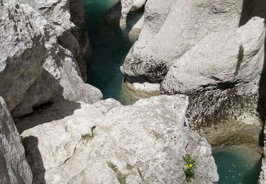
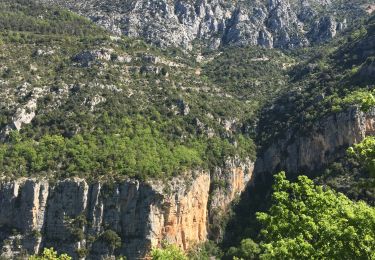
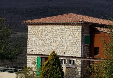
Trail Walking of 14.4 km to be discovered at Provence-Alpes-Côte d'Azur, Alpes-de-Haute-Provence, La Palud-sur-Verdon. This trail is proposed by LtZIP.

Description

Attention, le dénivelé n'est pas forcement exact et le chemin comporte de nombreuses "marches" cassantes.

Elevation profile

Photos

Positioning

Country:
France
Region :
Provence-Alpes-Côte d'Azur
Department/Province :
Alpes-de-Haute-Provence
Municipality :
La Palud-sur-Verdon
Location:
Unknown
Start:(UTM)
286316 ; 4847195 (32T) N.

Trails nearby

Trail Walking Aiguines - Belvédère, gorges, Inbut, sentier Vidal - Photo
Walking
MarcLEBARON

Walking

Difficult
(3)
Aiguines, Provence-Alpes-Côte d'Azur, Var, France
9.3 km | 20 km-effort
3h 35min
Yes
Trail Walking La Palud-sur-Verdon - Sentier Blanc-Martel - Photo
Walking
i20

Walking

Medium
(2)
La Palud-sur-Verdon, Provence-Alpes-Côte d'Azur, Alpes-de-Haute-Provence, France
15.4 km | 31 km-effort
Unknown
No
Trail Walking La Palud-sur-Verdon - Verdon : Sentier Blanc Martel - Photo
Walking
manumax

Walking

Medium
(1)
La Palud-sur-Verdon, Provence-Alpes-Côte d'Azur, Alpes-de-Haute-Provence, France
16.1 km | 39 km-effort
6h 43min
No
Trail Walking La Palud-sur-Verdon - bastidon - Photo
Walking
xav34830

Walking

Medium
(1)
La Palud-sur-Verdon, Provence-Alpes-Côte d'Azur, Alpes-de-Haute-Provence, France
18.4 km | 33 km-effort
Unknown
Yes
Trail Walking La Palud-sur-Verdon - Sentier Blanc Martel - Photo
Walking
ETMU5496

Walking

Difficult
La Palud-sur-Verdon, Provence-Alpes-Côte d'Azur, Alpes-de-Haute-Provence, France
15.6 km | 31 km-effort
6h 57min
No
Trail Walking La Palud-sur-Verdon - 2023-03-24 Bastidon - Ravin du Brusc - Photo
Walking
GUIDE
Kargil

Walking

Difficult
La Palud-sur-Verdon, Provence-Alpes-Côte d'Azur, Alpes-de-Haute-Provence, France
13.3 km | 25 km-effort
5h 19min
No
Trail Walking Aiguines - Sentier de l'imbut - Photo
Walking
Indi34

Walking

Medium
Aiguines, Provence-Alpes-Côte d'Azur, Var, France
10.4 km | 27 km-effort
4h 0min
Yes
Trail Walking Aiguines - Gorges du Verdon - Sentier de l'Imbut - Photo
Walking
PiloudeBamako

Walking

Very difficult
Aiguines, Provence-Alpes-Côte d'Azur, Var, France
11.3 km | 33 km-effort
3h 35min
No
Trail Walking La Palud-sur-Verdon - Verdon, le sentier Martel - Photo
Walking
liocol

Walking

Difficult
La Palud-sur-Verdon, Provence-Alpes-Côte d'Azur, Alpes-de-Haute-Provence, France
13.2 km | 26 km-effort
5h 24min
No


Close
My subscriptions